
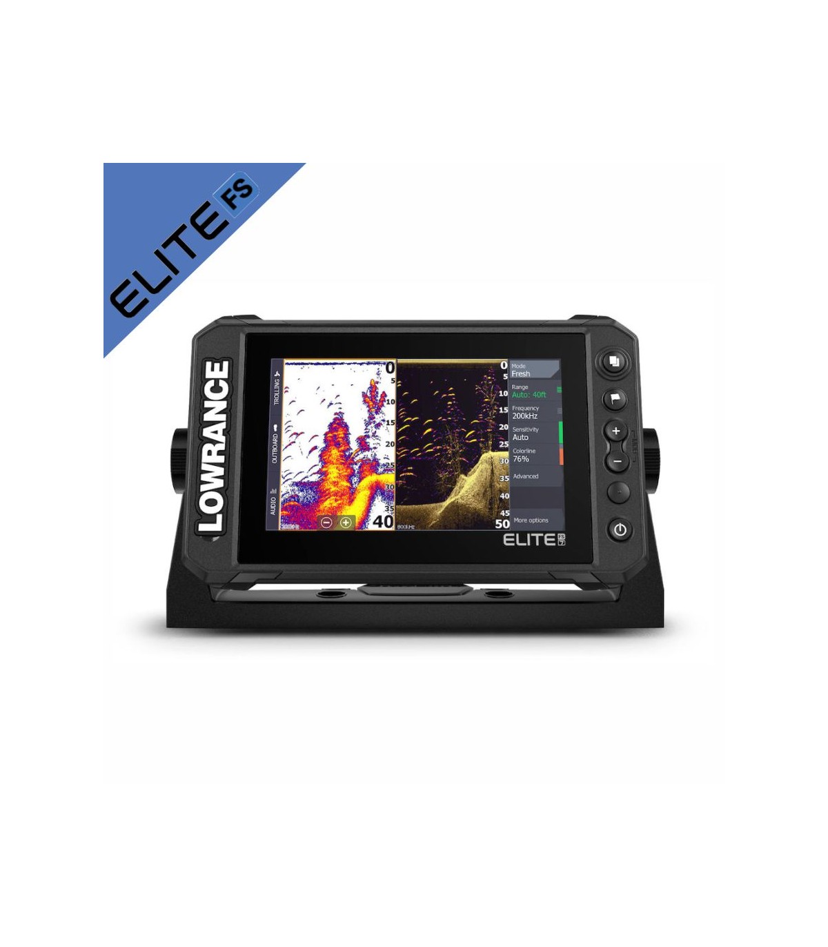

Elite FS7 GPS Plotter Sonar without transducer 000-15702-001
The new Elite Fishing System (FS) gives you access to Lowrance's full line of fish-finding tools, including ActiveTarget™ real-time sonar, Active Imaging™, and support for a wide range of fishfinding options. card, so you can get the most out of your time on the water.
Recommended Accessories
Accesorios electronica


C-MAP Discover has the best of C-MAP high-resolution blending, including Genesis's integrated data, along with vector graphics with all functions, personalized depth shading, tides and currents and Easy Routing without subscription. |
C-Map Discover L:Canaries, Madeira/Azores M-EW-Y209-MS |
|


The C-MAP REVEAL cartography features high-quality Premium graphics, including all REVEAL functions and data, as well as the new global shaded relief, satellite images, air photographs and plot graphics. Ideada para Lowrance, Simrad and B fakeG. Whether you are a sailor or an experienced fisherman these extraordinary cards will improve your fishing or sailing days. |
Cartografia C-Map Reveal Larga - West of Europe M-EW-Y228-MS |
|


High performance battery based on a soul of Lithium Ion cells of the highest quality, Power kit presents this product under the criteria of maximum efficiency and utility with a weight of only 650 gr you can take it anywhere. The main characteristics are its lightness, safety, durability and reliability, which together with its resistance to the marine environment (waterproof) make it one of the best options on the market.
Powerymax |
Complete battery kit Powerkit lithium 12V 10Ah |
|


The MAX Pro suitcase is made of high impact resistant ABS and has an IP67 certified outer shell, which means that it is 100% protected against dust and completely submerged in water at less than 1 meter for up to 30 minutes. The case guarantees great durability and can be used in different applications, from marine uses to photography, fishing, mountain activities or to transport your electronic devices. |
Briefcase waterproof box 280X230X155 w/foam 7" |
|


C-MAP Discover has the best of C-MAP high-resolution blending, including Genesis's integrated data, along with vector graphics with all functions, personalized depth shading, tides and currents and Easy Routing without subscription. |
Cartography C-Map Discover West Mediterranean M-EM-Y200-MS |
|


C-MAP Discover has the best of C-MAP high-resolution blending, including Genesis's integrated data, along with vector graphics with all functions, personalized depth shading, tides and currents and Easy Routing without subscription. |
Cartografia C-Map Discover Norte de España M-EW-Y207-MS |
|


The C-MAP REVEAL cartography features high-quality Premium graphics, including all REVEAL functions and data, as well as the new global shaded relief, satellite images, air photographs and plot graphics. Ideada para Lowrance, Simrad and B fakeG. Whether you are a sailor or an experienced fisherman these extraordinary cards will improve your fishing or sailing days. |
Cartografia C-Map Reveal Larga - Southwest of Europe M-EM-Y076-MS |


The Elite Fishing System™ (FS) combines the power of Lowrance's latest sonar features with a more affordable display that's easier to use and install. From ActiveTarget™ real-time sonar and impressive high-resolution Active Imaging™ with Lowrance CHIRP, SideScan and DownScan Imaging™ sonar, to support for a wide variety of mapping options, Elite FS gives you all the tools you need. to search and catch more fish.
Find more fish with Lowrance's exclusive sonar technology
See structure and coverage in a new level of detail and at unmatched range with 3-in-1 Active Imaging™ sonar, equipped with CHIRP, SideScan and DownScan with FishReveal™. Get the most out of CHIRP sonar and DownScan Imaging™ on one screen with FishReveal, an exclusive Lowrance feature that helps you easily distinguish fish from structure and coverage with highly detailed DownScan images amazing.
Locate fish in real time with new ActiveTarget™ real-time sonar
With ActiveTarget™ real-time sonar, you'll fish smarter by knowing exactly what your fish are doing, in real time. Enjoy high-resolution views of fish movements that allow you to track them as they enter cover and swim around you. Watch their response to the bait in real time and you'll know if your current technique is working or if it's time to change your strategy.
Lots of mapping options
Preloaded with a basic world map, Elite FS displays offer support for a wide range of mapping options, including C-MAP®, Navionics® and more.
Main features
- Compatible with ActiveTarget™ real-time sonar
- Compatible with Active Imaging 3 in 1
- Includes HDI transducer with CHIRP sonar and Lowrance DownScan Imaging™
- FishReveal™
- With basic world map, plus a wide range of chart options, including C-MAP, Navionics® and more
- Support for C-MAP® Easy Routing and Navionics® Autorouting
- On-screen C-MAP Genesis Live cartography
- High resolution multi-touch screen
- Integrated wireless, NMEA 2000® and Ethernet connectivity
- Full touchscreen control of Power Pole® anchors and Ghost® electric motor
Electrical
| Power Consumption, max. | 2.0A @ 13VDC with backlight on full |
|---|---|
| Power Consumption, min. | 2.0A @ 13VDC with backlight on full |
| Power Consumption, typical | 2.0A @ 13VDC with backlight on full |
| Recommended Fuse Rating | 3A |
| Supply Voltage | 12v DC (10.8-17VDC) |
| Humidity | 60°C, 95% relative humidity (RH) for 18 hours |
Environment
| Operating Temperature Range | 5°F to 131°F (-15°C to 55°C ) |
|---|---|
| Shock and Vibration | 100,000 cycles of 20 G |
| Storage Temperature Range | 4°F to 140°F (-20°C to 60°C ) |
| Waterproof rating | IPX7 with card door closed |
Gps
| Correction | DGPSWAASMSASEGLONASS |
|---|---|
| GPS Receiver Channels | 16 |
| Position Accuracy | 20m RMS |
| Time to First Fix | 30s |
| Update rate | 10Hz |
MFD
| AIS | AIS Chart overlay. Target vessel details. |
|---|---|
| Autopilot | Outboard PilotGhost Trolling MotorMotorGuide Xi5/Xi3 Trolling Motor **requires Motorguide PinPoint Gateway |
| Cartography included | C-MAP ROW Basemap (ROW models)Navionics basemap (AMER, AUS/NZ and ROW models) |
| Cartography supported | C-MAP (MAX N, MAX N+)C-MAP GenesisC-MAP Precision Contour HD (AMER ONLY)Navionics (Gold, NAV+ Platinum+)Insight (Pro and HD)Lowrance Regional Mapping Partners |
| Digital switching | None |
| External storage | 1 microSD card up to 32GB |
| Gps | 10 Hz Internal high-sensitivity WAAS + EGNOS + MSAS |
| Internal storage | None |
| Multimedia | SonicHubSonicHub2FusionLink productsany NMEA 2000 compliant Marine Aduio products |
| Radar (inc. compatibility) | 4G (Broadband)3G (Broadband)Halo20 (Pulse Compression Dome Radar)Halo20+ (Pulse Compression Dome Radar)Halo24 (Pulse Compression Dome Radar) |
| Sonar (inc. compatibility) | Integrated: CHRPBroadbandActive Imaging DownScanActive Imaging SideScanCompatible with:SonarHubStructureScanStructurreScan 3DLiveSightActive Target |
| Weather | SiriusXM via WM-4 (USA only) |
| Waypoints, Routes, Tracks | 3000 Waypoints100 Routes100 Trails with up to 10,000 points per trail |
| Compass Safe Distance - Metric, imperial | 12" (300mm) |
Physical
| MountingType | Gimbal Bracket or Dash Flush Mount |
|---|---|
| Weight | 1.90lbs (0.90kg) |
Other
Standard Language Pack: Afrikaans/Afrikaans, Danish/Dansk, German/Deutsch, English (US), English (UK), Spanish/Español, Finnish/Suomi, French/Français, Greek/Ελληνικά, Icelandic/íslenska, Italian/Italiano, Dutch/Nederlands, Norwegian/Norsk, Portugese (Brazil)/Português (BR), Portugese (Portugal)/Português (PT), Swedish/SvenskaAsian Language Pack: English (US), English (UK), Japanese/日本語, Korean /한국어, Thai/ภาษาไทย, Chinese - (simplified) China/简体中文, Chinese - (traditional) Taiwan/繁體中文Eastern European Language Pack:Bulgarian/Български, German/Deutsch, Estonian/Eesti, English (US), English (UK) pack: German/Deutsch, English (US), English (UK), Spanish/Español, Italian/Italiano, Russian/Русский, Ukraine/ УкраїнськаMiddle Eastern Language Pack: Arabic (UAE)/ العربية , German/D eutsch, English (US), English (UK), Farsi/ فارسی , French/Français, Italian/Italiano| Warranty Period | 1 Year + 4 additional years of upgrade options Totaling 5 years |
|---|---|
| Interface | Multi-Touch TouchscreenZoom +/-MOB = (+/- combined)PagesWaypointLight/Power |
| Languages |
| acklight Color | Pure White LED |
|---|---|
| Resolution | 800x480 |
| Screen Brightness | >1200nits |
| Size and Type | 7.00" (178mm) WVGA color TFT LCD |
| Viewing Angles | 50°top60°bottom70°left/right |
Data sheet
- Product
- GPS Plotter Sounder
- Gama/family
- Elite FS
- Size screen
- 7"
- PMA Transductor
- 1 kW