
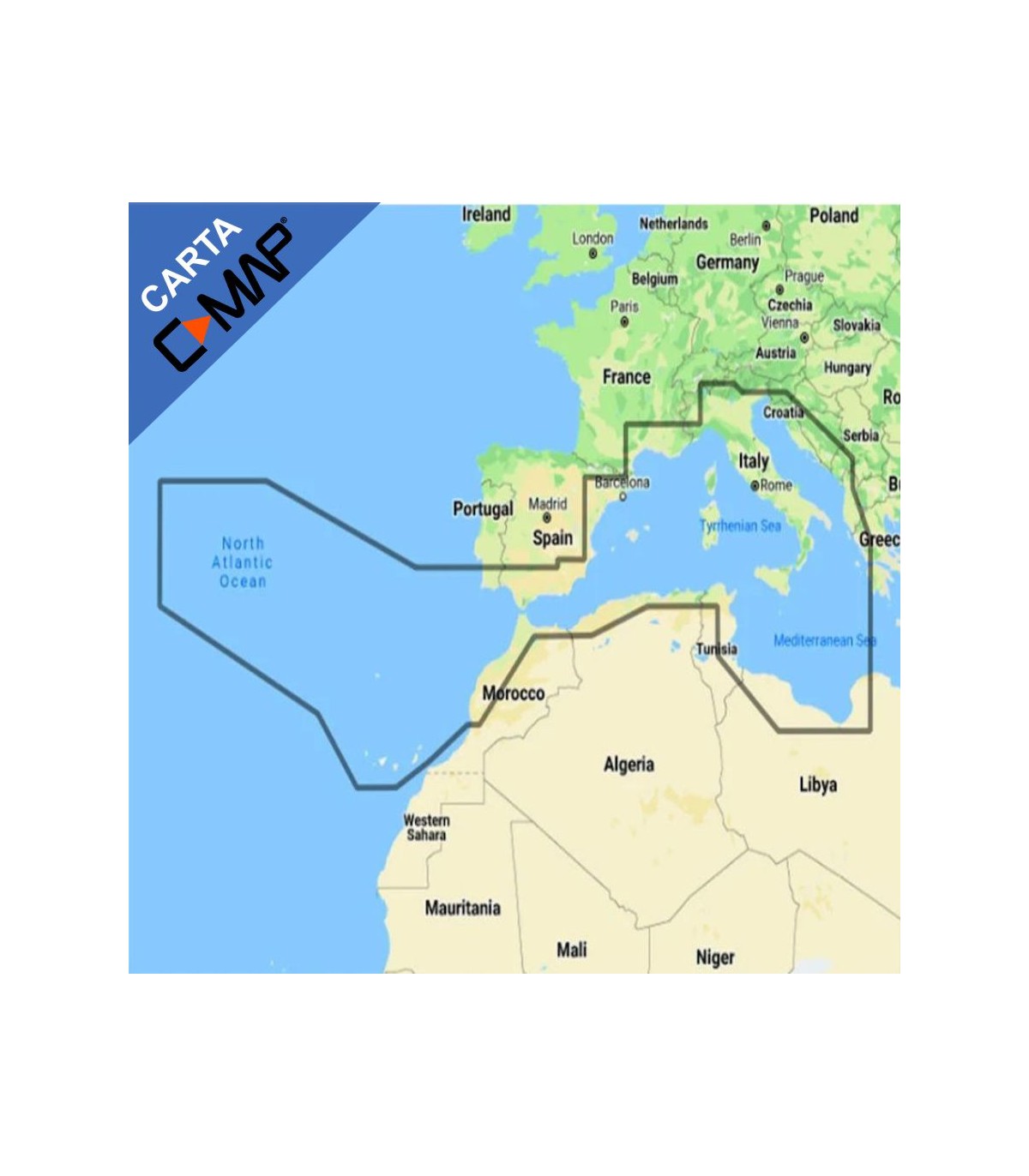

Cartografia C-Map Reveal Larga - Southwest of Europe M-EM-Y076-MS

The C-MAP REVEAL cartography features high-quality Premium graphics, including all REVEAL functions and data, as well as the new global shaded relief, satellite images, air photographs and plot graphics. Ideada para Lowrance, Simrad and B fakeG. Whether you are a sailor or an experienced fisherman these extraordinary cards will improve your fishing or sailing days.
Main Features C-MAP REVEAL Large Cartography:
Letters in vector format with full functions
High resolution batterymetry
Genesis Data
Custom depth shading
Free subscription to Easy RoutingTM
Mareas and currents
Detailed plans of marinas
Multilingual
Protected marine areas*
12 months of free online updates
C-MAP Survey Lake Data
Raster letters
Air photographs*
Satellite images*
Hatted fold: standard
Sombre fold: 3D
Explore the main functions C-MAP REVEAL Large Cartography:
CHARTERS IN VECTORIAL FORMATO WITH COMPLETE FUNTIONS: Letters in vector format with full functions facilitate navigation, as they offer precise and updated details obtained from the official information of the hydrographic agency.
ALTA BATIMETRY CAPA RESOLUTION: The high-resolution batimetry layer (HRB) allows slopes, outgoings, pozas and mounds.
PERSONALIZED PROFCONDITY SOMETHING: Personalized depth shading provides many options to establish a safety depth, a view similar to that of paper or your own custom color for depths.
SENCILLA DE RUTAS PLANIFICATION: Easy Routing allows you to automatically trace the shortest and safest route based on the detailed data of the letter and the information on the boat of the user.
C-MAP GENESIS CAPA: The C-MAP Genesis layer adds depth lines of 1 foot to traditional C-MAP cards, compiled from Social Map of Genesis.
♪ The shaded relief gives life to the world around your boat with a three-dimensional reproduction of the underwater background and elevation. **Not available at Continental or Insight Pro
SUPERPOSITION OF IMAGES BY SATÉLITE** The overlap of satellite images overprints satellite images to offer you more information about your environment when you are in an unknown location. **Not available at Continental or Insight Pro
RÁSTER CARTAS: Raster letters provide the appearance and sensations of the traditional letter, in addition to facilitating access to all the objects of the letter.
AEREA PHOTOGRAPHS** Aerial photographs are a collection of thousands of photos of marinas, docking ports, ensenadas and other outstanding navigation features that are included to offer an additional level of detail. **Not available at Continental or Insight Pro
MAREAS AND CORRIENTES: Show water level projections and tide management to help you plan your day of fishing or navigation.
APPROXIMATION DETAILS AND OPPORTS: An unprecedented level of detail that allows the sailors to approach any port or to enter with confidence. The perfect closure for a long journey, a sailing adventure or an exciting day of fishing.
DETAILED PLANOS DEPORTIVOS: Attracting into an unknown port does not pose a problem if it has the precise planes of thousands of marinas, including the tray zones, restricted areas and other important navigation information
Lowrance compatibility
HDS GEN 2 ( 5, 5m, 7, 7m, 8, 8m, 10, 10m)
HDS GEN 2 Touch (7, 7m, 9, 9m, 12m)
HOOK2 (5, 7, 9 and 12)
HOOK REVEAL (7, 9)
HDS GEN 3 (7, 9, 12)
ELITE Ti, TI2 (5, 7, 9, 12)
HDS CARBON (7, 9, 12, 16)
HDS LIVE (7, 9, 12 and 16)
Compatibility Simrad
NSO (8, 12)
NSE (8, 12)
NSO Evo2
NSS Evo2 (7, 7m, 9, 9m, 12, 16)
NSS Evo3 (7, 9, 12, 16)
NSS Evo3s (7,9, 12 and 16)
GO (5, 5XSE, 7, 7XSE, XSR, 9XSE)
CRUISE (5, 7 and 9)
Compatibility B blindG
Zeus2 (7, 9, 12)
Zeus2 Touch Glass Helm
Zeus3 (7, 9, 12, 16)
Vulcan (5, 7, 9)