

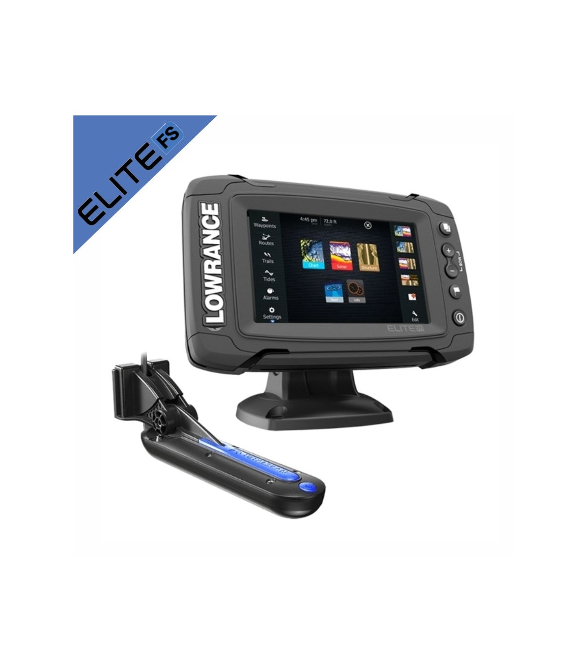

Elite-5 Ti GPS probe with Mid/High/TotalScan 000-14517-001 transducer
Lowrance Elite 5 TI DownScan Fishfinder-Plotter with Transducer Mid/High CHIRP (83/200kHz) 455/800 kHz DownScan™, Low/High CHIRP (50/200kHz) . Powerful high-end Elite 5 TI DownScan Fishfinder/Plotter and GPS with high performance and touch screen. It has Bluetooth and built-in wireless connectivity. It is easy to use and has wireless bluetooth connectivity. Thanks to its 5-inch color touch screen, you will enjoy excellent image quality. Includes HDI/CHIRP transducer sonar.
Recommended Accessories
Accesorios electronica


High performance battery based on a soul of Lithium Ion cells of the highest quality, Power kit presents this product under the criteria of maximum efficiency and utility with a weight of only 650 gr you can take it anywhere. The main characteristics are its lightness, safety, durability and reliability, which together with its resistance to the marine environment (waterproof) make it one of the best options on the market.
Powerymax |
Complete battery kit Powerkit lithium 12V 10Ah |
|


The MAX Pro suitcase is made of high impact resistant ABS and has an IP67 certified outer shell, which means that it is 100% protected against dust and completely submerged in water at less than 1 meter for up to 30 minutes. The case guarantees great durability and can be used in different applications, from marine uses to photography, fishing, mountain activities or to transport your electronic devices. |
Briefcase waterproof box 235X187X95 w/foam 4" - 5" |
|


The C-MAP REVEAL cartography features high-quality Premium graphics, including all REVEAL functions and data, as well as the new global shaded relief, satellite images, air photographs and plot graphics. Ideada para Lowrance, Simrad and B fakeG. Whether you are a sailor or an experienced fisherman these extraordinary cards will improve your fishing or sailing days. |
Cartografia C-Map Reveal Larga - West of Europe M-EW-Y228-MS |
|


C-MAP Discover has the best of C-MAP high-resolution blending, including Genesis's integrated data, along with vector graphics with all functions, personalized depth shading, tides and currents and Easy Routing without subscription. |
C-Map Discover L:Canaries, Madeira/Azores M-EW-Y209-MS |
|


The C-MAP REVEAL cartography features high-quality Premium graphics, including all REVEAL functions and data, as well as the new global shaded relief, satellite images, air photographs and plot graphics. Ideada para Lowrance, Simrad and B fakeG. Whether you are a sailor or an experienced fisherman these extraordinary cards will improve your fishing or sailing days. |
Cartografia C-Map Reveal Larga - Southwest of Europe M-EM-Y076-MS |
|


C-MAP Discover has the best of C-MAP high-resolution blending, including Genesis's integrated data, along with vector graphics with all functions, personalized depth shading, tides and currents and Easy Routing without subscription. |
Cartografia C-Map Discover Norte de España M-EW-Y207-MS |
|


C-MAP Discover has the best of C-MAP high-resolution blending, including Genesis's integrated data, along with vector graphics with all functions, personalized depth shading, tides and currents and Easy Routing without subscription. |
Cartography C-Map Discover West Mediterranean M-EM-Y200-MS |


Key points
5" one-touch widescreen
Built-in Chirp / Broadband Sonar
Built-in StructureScan™ (with TotalScan transducer)
Built-in 10Hz GPS/GLONASS antenna
Built-in wireless connectivity
Built-in Bluetooth connectivity
Best-in-class screen brightness
Single micro SD card slot
Wide selection of mapping options
Uses quick release mount
Points of sale
Standalone Fishfinder/Chartplotter
Detailed basemap cartography (Americas models) and Navionics basemap (Americas and ROW)
Add cartography available from C-MAP, Navionics and other regional mapping partners
Fully customizable split screen options
StructureMap included with built-in StructureScan.
General
Display Size 5in (127mm) Diag.
Screen type WVGA color TFT LCD
Resolution 800H x 480W
Pure White LED Backlight
Screen brightness 1200 nits
Height 5.309in (134.85mm)
Width 6.933in (176.10mm)
Depth 2.421in (61.50mm)
Weight 3.04lbs (1.38kg)
Environmental
Operating temperature 5°F to 131°F (-15°C to 55°C)
IPX7 waterproof with card door closed
DOC Part 15.103 FCC Rules and CE RTTE Directive 1999/5/EC
Electric
Current draw of 0.9A at 13VDC with backlight on
Operating voltage 12VDC
Supply voltage 10.8-17VDC
User interface
One-touch touch interface and limited keyboard; ZOOM +/-, WPT, LIGHT / POWER
Chart Plotter Features
Display modes North, Course Up (COG), Heading Up (Heading with External Heading Sensor or COG)
Built-in cartography Detailed basemap cartography (AMER models), Navionics basemap (AMER and ROW models)
Add Navico Insight HD Cartography, Navionics Platinum + / Platinum / Gold, Fishing HotSpots
Alarms No GPS Fix, Anchor, Low Boat Speed, XTE, Waypoint Radius, Arrival
Sound Features
Built-in CHIRP Yes
Built-in Broadband Yes
Built-in StructureScan Yes
Sonar Frequency Mid/High CHIRP (83/200kHz) 455/800 kHz DownScan™, Low/High CHIRP (50/200kHz)
(* Available frequencies determined by connected transducer)
Broadband Power 500W RMS
Sonar DownScan ™ Depth max. 455/800kHz 300ft (91m)
Sonar Broadband Max Depth Low / High (50/200 kHz) transducer 3000ft (762m)
Sonar Broadband Max Depth Medium / High (83/200 kHz) transducer 1000ft (305M)
Sonar Alarms Fish, Shallow
Track Back Yes
Temperature readings Yes
Communications / Interface
NMEA0183 1 x RS422 port
Supported Baud Rates 1200, 2400, 4800 (default), 9600, 19200, 38400, 57600, 115200
Data card Slot 1 micro SD card up to 32GB
GPS navigation
High sensitivity internal GPS type WAAS + EGNOS + MSAS
Waypoints 3000
Routes 100
Trails 100 plots with up to 10,000 points per trail
GPS alarms anchor, arrival, appointment
World Reference Basemap and US Enhanced Basemap with over 3,000 enhanced lake maps with depth contour and shoreline details, plus coastal depth contours/shoreline details and spot depth soundings a 1,000ft./305m
Lake Insight™ and Nautic Insight™ PRO and HD, Navionics® Gold and HotMaps® Premium, Fishing Hotspots® PRO and Jeppessen C-Map Max-N Wide mapping options.
Data sheet
- Product
- GPS Plotter Sounder
- Gama/family
- Elite FS
- Size screen
- 5"
- Transducing power
- 500w