
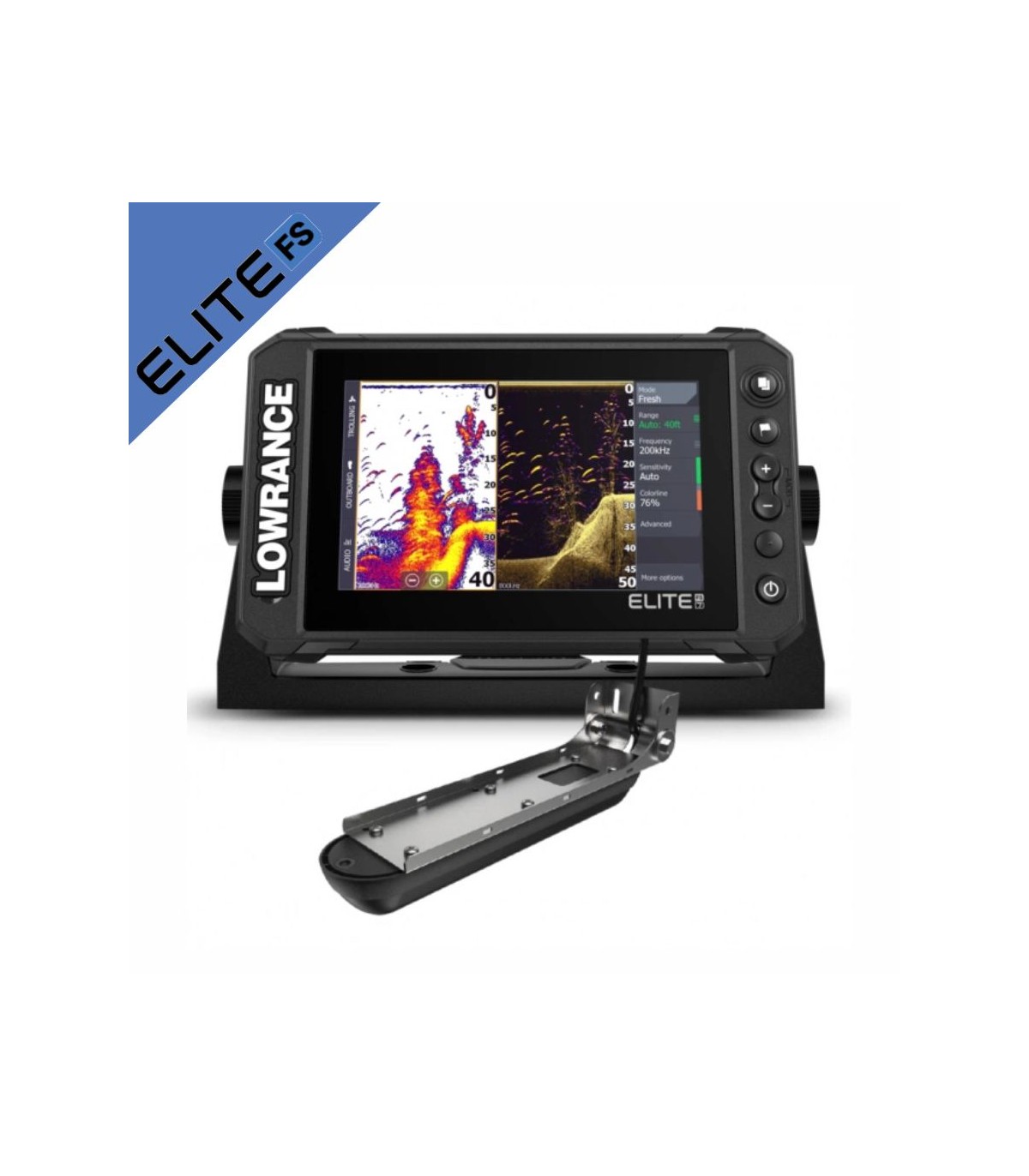

Sonda Lowrance GPS Elite FS7 con tranductor Active Imaging 3 en 1 000-15689-001
El nuevo Elite Fishing System (FS) te da acceso a la completa gama de funciones de sonda de Lowrance, entre las que se incluyen la sonda en tiempo real ActiveTarget™, Active Imaging™ y compatibilidad con una amplia variedad de opciones de cartografía, para que puedas sacarle el máximo partido al tiempo que pasas en el agua. Sonda CHIRP 83/200 kHz con DownScan/SideScan 455/800 kHz
Accesorios recomendados
Accesorios electronica


C-MAP Discover tiene lo mejor de la batimetría de alta resolución C-MAP, incluidos los datos integrados de Genesis, junto con gráficos vectoriales con todas las funciones, sombreado de profundidad personalizado, mareas y corrientes y Easy Routing sin suscripción. M-EW-Y209-MS |
Cartografia C-Map Discover L:Canarias, Madeira/Azores M-EW-Y209-MS |
|


La cartografía C-MAP REVEAL dispone de gráficos de altísima calidad Premium, incluye todas las funciones y datos REVEAL, además del nuevo relieve sombreado global, imágenes de satélite, fotografías aéreas y gráficos de trama. Ideada para Lowrance, Simrad y B&G. Tanto si eres un navegante o un experimentado pescador estas extraordinarias cartas mejorarán tus días de pesca o navegación. M-EW-Y228-MS |
Cartografia C-Map Reveal Larga - Oeste de Europa M-EW-Y228-MS |
|


Batería de alto rendimiento basada en un alma de células de Iones de Litio de la más alta calidad, Power kit presenta este producto bajo el criterio de la máxima eficiencia y utilidad con un peso de solo 650 gr podrás llevarla en cualquier parte. Las principales características son su ligereza, seguridad, durabilidad y fiabilidad que unidas a su resistencia al ambiente marino (waterproof) la hacen una de las mejores opciones del mercado. Powerymax |
Kit completo bateria Powerkit litio 12V 10Ah |
|


La maleta MAX Pro están fabricadas en ABS de alta resistencia al impacto y dispone de una carcasa exterior certificada IP67, lo que significa que está protegida contra el polvo al 100% y sumergida al agua totalmente a menos de 1 metro hasta 30 minutos. La maleta garantiza una gran durabilidad y puede utilizarse en diferentes aplicaciones, de usos marinos hasta fotografía, pesca, actividades de montaña o para transportar sus aparatos eléctrónicos. |
Maletin caja estanca 280X230X155 c/foam 7" |
|


C-MAP Discover tiene lo mejor de la batimetría de alta resolución C-MAP, incluidos los datos integrados de Genesis, junto con gráficos vectoriales con todas las funciones, sombreado de profundidad personalizado, mareas y corrientes y Easy Routing sin suscripción. |
Cartografia C-Map Discover Oeste Mediterraneo M-EM-Y200-MS |
|


C-MAP Discover tiene lo mejor de la batimetría de alta resolución C-MAP, incluidos los datos integrados de Genesis, junto con gráficos vectoriales con todas las funciones, sombreado de profundidad personalizado, mareas y corrientes y Easy Routing sin suscripción. |
Cartografia C-Map Discover Norte de España M-EW-Y207-MS |
|


La cartografía C-MAP REVEAL dispone de gráficos de altísima calidad Premium, incluye todas las funciones y datos REVEAL, además del nuevo relieve sombreado global, imágenes de satélite, fotografías aéreas y gráficos de trama. Ideada para Lowrance, Simrad y B&G. Tanto si eres un navegante o un experimentado pescador estas extraordinarias cartas mejorarán tus días de pesca o navegación. M-EM-Y076-MS |
Cartografia C-Map Reveal Larga - Suroeste de Europa M-EM-Y076-MS |
El Elite Fishing System™ (FS) combina la potencia de lo último en funciones de sonda de Lowrance con una pantalla más asequible que resulta más fácil de usar e instalar. Desde la sonda en tiempo real ActiveTarget™ y la impresionante alta resolución de Active Imaging™ con sonda CHIRP, SideScan y DownScan Imaging™ de Lowrance, hasta la compatibilidad con una amplia variedad de opciones de cartografía, Elite FS te ofrece todas las herramientas que necesitas para buscar y atrapar más peces.
Encuentra más peces con la exclusiva tecnología de sonda de Lowrance
Observa la estructura y la cobertura con un nuevo nivel de detalle y a un alcance sin igual gracias a la sonda Active Imaging™ 3 en 1, equipada con CHIRP, SideScan y DownScan con FishReveal™. Saca el mejor partido posible de la sonda CHIRP y DownScan Imaging™ en una sola pantalla con FishReveal, una función exclusiva de Lowrance, que te ayuda a diferenciar fácilmente los peces de la estructura y la cobertura gracias a las imágenes DownScan con un nivel de detalle increíble.
Localiza peces en tiempo real con la nueva sonda en tiempo real ActiveTarget™
Con la sonda en tiempo real ActiveTarget™ pescarás de una forma más inteligente al saber qué están haciendo los peces exactamente, en tiempo real. Disfruta de vistas en alta resolución de los movimientos de los peces que te permitirán rastrearlos mientras entran en la cobertura y nadan a su alrededor. Observa su respuesta al cebo en tiempo real y sabrás si tu técnica actual funciona o si es la hora de cambiar de estrategia.
Gran cantidad de opciones de cartografía
Las pantallas Elite FS, que incluyen un mapa mundial básico precargado, ofrecen compatibilidad con una amplia gama de opciones de cartografía, entre las que se incluyen C-MAP®, Navionics® y más.
Características principales
- Compatible con la sonda en tiempo real ActiveTarget™
- Compatible con Active Imaging 3 en 1
- FishReveal™
- Con mapa mundial básico, además de una amplia gama de opciones de carta, entre las que se incluyen C-MAP, Navionics® y más
- Funciones Easy Routing de C-MAP® y Autorouting de Navionics®
- Cartografía Genesis Live de C-MAP en pantalla
- Pantalla multitáctil de alta resolución
- Conectividad inalámbrica, NMEA 2000® y Ethernet integrada
- Control total mediante pantalla táctil de las anclas Power Pole® y el motor eléctrico Ghost®
Electrical
| Power Consumption, max. | 2.0A @ 13VDC with backlight on full |
|---|---|
| Power Consumption, min. | 2.0A @ 13VDC with backlight on full |
| Power Consumption, typical | 2.0A @ 13VDC with backlight on full |
| Recommended Fuse Rating | 3A |
| Supply Voltage | 12v DC (10.8-17VDC) |
| Humidity | 60°C, 95% relative humidity (RH) for 18 hours |
Environment
| Operating Temperature Range | 5°F to 131°F (-15°C to 55°C ) |
|---|---|
| Shock and Vibration | 100,000 cycles of 20 G |
| Storage Temperature Range | 4°F to 140°F (-20°C to 60°C ) |
| Waterproof rating | IPX7 with card door closed |
GPS
| Correction | DGPSWAASMSASEGNOSGLONASS |
|---|---|
| GPS Receiver Channels | 16 |
| Position Accuracy | 20m RMS |
| Time to First Fix | 30s |
| Update rate | 10 Hz |
MFD
| AIS | AIS Chart overlay. Target vessel details. |
|---|---|
| Autopilot | Outboard PilotGhost Trolling MotorMotorGuide Xi5/Xi3 Trolling Motor **requires Motorguide PinPoint Gateway |
| Cartography included | C-MAP ROW Basemap (ROW models)Navionics basemap (AMER, AUS/NZ and ROW models) |
| Cartography supported | C-MAP (MAX N, MAX N+)C-MAP GenesisC-MAP Precision Contour HD (AMER ONLY)Navionics (Gold, NAV+ Platinum+)Insight (Pro and HD)Lowrance Regional Mapping Partners |
| Digital Switching | None |
| External Storage | 1 micro SD card up to 32GB |
| GPS | 10 Hz Internal high-sensitivity WAAS + EGNOS + MSAS |
| Internal Storage | None |
| Multimedia | SonicHubSonicHub2FusionLink productsany NMEA 2000 compliant Marine Aduio products |
| Radar (inc. compatibility) | 4G (Broadband)3G (Broadband)Halo20 (Pulse Compression Dome Radar)Halo20+ (Pulse Compression Dome Radar)Halo24 (Pulse Compression Dome Radar) |
| Sonar (inc. compatibility) | Integrated: CHIRPBroadbandActive Imaging DownScanActive Imaging SideScanCompatible with:SonarHubStructureScanStructurreScan 3DLiveSightActive Target |
| Weather | SiriusXM via WM-4 (USA only) |
| Waypoints, Routes, Tracks | 3000 Waypoints100 Routes100 Trails with up to 10,000 points per trail |
| Compass Safe Distance - Metric, imperial | 12" (300mm) |
Physical
| Mounting Type | Gimbal Bracket or Dash Flush Mount |
|---|---|
| Weight | 1.90 lbs (0.90 kg) |
Other
Standard Language Pack: Afrikaans/Afrikaans, Danish/Dansk, German/Deutsch, English (US), English (UK), Spanish/Español, Finnish/Suomi, French/Français, Greek/Ελληνικά, Icelandic/íslenska, Italian/Italiano, Dutch/Nederlands, Norwegian/Norsk, Portugese (Brazil)/Português (BR), Portugese (Portugal)/Português (PT), Swedish/SvenskaAsian Language Pack: English (US), English (UK), Japanese/日本語, Korean/한국어, Thai/ภาษาไทย, Chinese - (simplified) China/简体中文, Chinese - (traditional) Taiwan/繁體中文Eastern European Language Pack:Bulgarian/Български, German/Deutsch, Estonian/Eesti, English (US), English (UK), Spanish/Español, French/Français, Hebrew/ عبری , Croatian/ Hrvatski, Hungarian/ Magyar, Italian/Italiano, Lithuanian/Lietuvos, Latvian/ Latvijas, Polish/Polski, Slovak/ Slovensky, Turkish/TürkçeRussia/Ukraine Language pack: German/Deutsch, English (US), English (UK), Spanish/Español, Italian/Italiano, Russian/Русский, Ukraine/ УкраїнськаMiddle Eastern Language Pack: Arabic (UAE)/ العربية , German/Deutsch, English (US), English (UK), Farsi/ فارسی , French/Français, Italian/Italiano| Warranty Period | 1 Year + 4 additional years ofupgrade optionsTotaling 5 years |
|---|---|
| Interface | Multi-Touch TouchscreenZoom +/-MOB = (+/- combined)PagesWaypointLight/Power |
| Languages |
| Backlight Color | Pure White LED |
|---|---|
| Resolution | 800x480 |
| Screen Brightness | >1200 nits |
| Size and Type | 7.00" (178mm) WVGA color TFT LCD |
| Viewing Angles | 50° top60°bottom70° left/right |
Ficha de datos
- Producto
- Sonda Plotter GPS
- Gama/familia
- Elite FS
- Tamaño pantalla
- 7"
- Potencia transductor
- 300w
- PM Admisible Transd.
- 1Kw